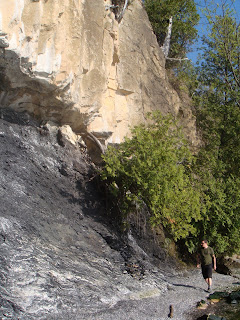
The Champlain Thrust was formed about 500 million years ago when two plates collided and overlapped. The upper plate is Dunham Dolostone; a carbonate rock plate thrust 35 - 50 miles over the Iberville Formation, which is composed of shale with calcite veins. Interestingly, the Cambrian Dunham Dolostone is older than Iberville Shale, which dates to the Ordovician. The fault extends from Canada to the Catskill Plateau, almost 200 miles. In the picture below, A is the Dunham Dolostone and B is the Iberville Shale, which has eroded away greatly.

If I knew more about geology, I'd go into more detail, but beyond what I've already written, I just don't really understand what I'm reading about! Something about slicklines...which I assume are grooves in the stone made by the movement of the plates against one another. They're supposed to be on the bottom face of the Dolostone. Here's a picture of the underside of the dolostone plate:
Are the lines extending from the upper right to lower left slicklines?
The shale was so eroded that it was almost powdery in some places, which made climbing around somewhat dangerous and very dirty. It was well worth it, though, to get up close to the rock and see the view of the lake from high up.


The geology of the area was only a piece of what made the hike so interesting, but you'll have to wait until the next post to see some of the flora and fauna.
References:


3 comments:
The Champlain Thrust was formed about 500 million years ago when two plates collided and overlapped. The upper plate is Dunham Dolostone; a carbonate rock plate thrust 35 - 50 miles over the Iberville Formation, which is composed of shale with calcite veins. Interestingly, the Cambrian Dunham Dolostone is older than Iberville Shale, which dates to the Odovician.
Yes, this is typical of thrust faults, which are very low angle reverse faults. (There's lots of animations of various fault types on the web; here's just one.) Basically what happens in such situations, part of a plate is under compression -- it's being squeezed by opposing forces from two sides. This causes breakage (a fault) to accommodate the stress. In the case of a thrust fault, the break is at a low angle (less than 45 degrees from the horizontal; often 15 degrees or less), and one of the two "halves" rides up over the other one for some distance -- it is thrust up on top of and over the other one. As you probably know, layered rocks are deposited from the bottom up, so older layers are always beneath younger layers. Because of the thrust, older layers are slid over younger layers -- that's why in this instance you've got Cambrian-age rocks overlying younger Ordovician age rocks.
I like to try and illustrate various geologic processes with food for some reason: imagine you've got a big cracker (like a sheet of matzoh or something). If you push on opposite ends (and if the cracker cooperates and doesn't break where your hands are!), eventually the cracker will break into two (probably more) pieces, and one of them will be forced on top the other one. Where they overlap, the bottom of one piece is sitting on top of the top surface of the other piece. Congratulations -- you've just thrust faulted a cracker!
Of course, under the kinds of long-term stresses applied during tectonic activity, rock can behave in a more plastic fashion than the cracker does -- the rock layers will bend and contort as well as break, so somwhere, where the thrust fault isn't horizontal (the point at which the plate broke), you'd probably see the Dunham Dolostone flexed downward.
If I knew more about geology, I'd go into more detail, but beyond what I've already written, I just don't really understand what I'm reading about! Something about slicklines...which I assume are grooves in the stone made by the movement of the plates against one another.
These are probably slickensides, which are surfaces that have been basically polished smooth by the grinding action of movement on the fault; the polished, shiny areas do indeed possess grooves (slickenlines) that indicate the direction of movement (e.g., these). I don't think that's what you're seeing in the picture; those look like joints (breaks in the rock along which no movement has occurred, which differentiates them from faults) created by the movement of the faulted block. There may be slickensides on the surface in your picture, but you'd have to be closer up to see them. They can cover really expansive areas, though!
Post a Comment